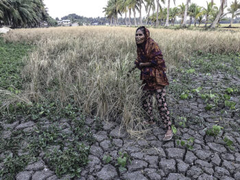
I visited Marawi City often long before the siege, and accumulated some photographs of the place over the years. Here are comparison pictures of a few areas before and after the 2017 war.
From afar, you can’t see much of the damage of the buildings. The upper shot was taken in 2004, the post siege picture was shot May 2019. Maybe the same spot, but the trees in the foreground have grown taller. MindaNews photo by BOBBY TIMONERAPlaza Cabili at Banggolo, in the heart of Marawi when Meranao men played kasipa sa manggis, photographed in 2008. The lower picture taken May 2018 during Kambisita, when residents were allowed to visit Ground Zero. MindaNews photo by BOBBY TIMONERAThe Grand Mosque’s dome was still pristine in 2002, compared to the damage done after the siege, as photographed in May 2018. MindaNews photo by BOBBY TIMONERABato Ali Mosque as photographed in 2005 and in April 2019. MindaNews photo by BOBBY TIMONERAAnother view of the Bato Ali Mosque sans the minaret, circa 2005, and in April 2019. MindaNews photo by BOBBY TIMONERAGomisa Ave. (formerly Quezon Ave.) during a parade for Araw ng Marawi in 2009 and during Kambisita in May 2018. MindaNews photo by BOBBY TIMONERAOpposIte view of Gomisa Ave. with the Signal Hill in the background. Upper photo taken in 2007, bottom in May 2018. MindaNews photo by BOBBY TIMONERAThe padian, or market area, as it was in 2007, and in May 2018. I’m not sure though if these were the same streets. MindaNews photo by BOBBY TIMONERA